Mapping Memory: The Enduring Power of Lenape Ancestral Lands
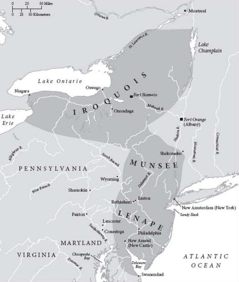
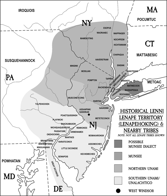
In the sprawling urban tapestry of the Eastern Seaboard, from the bustling streets of New York City to the historic avenues of Philadelphia, a profound and often unseen history lies beneath the asphalt and steel. It is the story of the Lenape people, the original inhabitants of a vast and fertile territory they called Lenapehoking, encompassing parts of modern-day New York, New Jersey, Pennsylvania, Delaware, and Connecticut. For centuries, their presence was woven into the very fabric of this land. Today, as awareness of Indigenous history grows, a powerful tool is emerging to help reclaim and re-contextualize this narrative: the Lenape ancestral lands map. More than just a cartographic representation, this map is a testament to resilience, a guide for reconciliation, and a stark reminder of the enduring legacy of colonialism.
The Lenape, or Lenni Lenape, meaning "Original People," were a sophisticated, matrilineal society with a rich culture deeply intertwined with the land. They lived in harmony with the natural world, their lives dictated by the seasons, their spiritual beliefs rooted in the interconnectedness of all living things. Lenapehoking, their ancestral homeland, was a vibrant landscape of forests, rivers, and coastal plains, teeming with life. They were skilled hunters, fishers, and farmers, cultivating corn, beans, and squash, and managing their environment sustainably for generations. Their society was organized into three main linguistic and geographical divisions: the Munsee in the north, the Unami in the central region, and the Unalachtigo in the south, each with their distinct dialects but united by shared cultural practices and a common heritage.
The arrival of European colonizers in the 17th century marked the beginning of an irreversible transformation. The Dutch, Swedes, and later the English, saw Lenapehoking not as a homeland, but as a resource-rich frontier to be exploited. Initial interactions, often driven by trade, soon devolved into conflicts fueled by misunderstanding, disease, and an insatiable hunger for land. European concepts of land ownership – individual, private, and alienable – clashed fundamentally with the Lenape understanding of land as a communal trust, a sacred entity to be cared for, not bought and sold.

One of the most infamous examples of this clash, and a pivotal moment in Lenape history, was the "Walking Purchase" of 1737. This fraudulent treaty, orchestrated by Pennsylvania colonial authorities, claimed a vast tract of land based on a vague 1686 agreement. The terms stated that the land conveyed would extend as far as a man could walk in a day and a half. Instead of a leisurely walk, the colonists employed three swift runners who covered an astonishing 65 miles, seizing an area equivalent to the entire state of Rhode Island – far more than the Lenape had ever intended to cede. This act of deception, coupled with relentless pressure, disease, and dwindling resources, forced the Lenape to begin a series of heartbreaking westward migrations.
The journey was long and arduous, pushing the Lenape from their beloved Lenapehoking through Ohio, Indiana, Missouri, Kansas, and eventually to Indian Territory (present-day Oklahoma). Other groups found refuge in Wisconsin and Ontario, Canada. Each stop was marked by further displacement, broken promises, and the trauma of cultural disruption. Yet, despite centuries of forced removal, assimilation policies, and the systemic erasure of their history, the Lenape people endured. They maintained their cultural identity, their languages, and their spiritual traditions, often in secret, passing them down through generations.
This is where the ancestral lands map becomes more than just a historical artifact; it transforms into a powerful contemporary tool. A typical Lenape ancestral lands map doesn’t just show current state lines; it overlays the vast, original expanse of Lenapehoking onto the modern geographical and political landscape. It highlights not only where the Lenape once lived, but crucially, where they still belong in the collective consciousness. It visualizes the scale of the injustice, making tangible the abstract concept of stolen land.
For educators, these maps are invaluable. They challenge the Eurocentric narratives often found in textbooks, providing a visual counter-story that emphasizes Indigenous sovereignty and presence. Students can see that the ground they stand on, the schools they attend, the parks they visit, are all built upon ancestral Lenape lands. This simple visual shift can spark profound conversations about history, justice, and responsibility.
For Indigenous communities, particularly the descendant Lenape nations spread across Oklahoma (Delaware Nation, Delaware Tribe of Indians), Wisconsin (Stockbridge-Munsee Community), and Ontario (Munsee-Delaware First Nation), the map is a source of pride and a symbol of their enduring connection to their original homelands. It represents a living memory, a powerful affirmation of their identity and a rallying point for cultural revitalization efforts. As one Lenape elder might say, "The map shows that our spirit is still in the rivers, in the mountains, in the very air of Lenapehoking. We are still here." This sentiment encapsulates the resilience and unbroken spiritual bond that transcends geographical distance.
The map also serves as a crucial foundation for the growing movement of land acknowledgments. In recent years, it has become increasingly common for institutions, organizations, and events, particularly in the Northeastern United States, to begin gatherings with a statement acknowledging the Indigenous peoples on whose traditional land they are meeting. These acknowledgments, while sometimes criticized as symbolic gestures, are a vital first step in recognizing historical injustices and initiating a process of decolonization. They force individuals and institutions to confront the true history of the land and acknowledge the original caretakers.
A typical land acknowledgment, informed by the ancestral map, might state: "We acknowledge that we are gathered on the ancestral lands of the Lenape people, who have stewarded this land for generations. We honor their past, present, and future contributions and commit to working towards a more just and equitable future." This simple act, repeated across countless venues, slowly but surely chips away at the historical invisibility of Indigenous peoples.
Beyond acknowledgment, the map inspires deeper forms of engagement. It prompts questions about environmental stewardship, given the Lenape’s traditional ecological knowledge and their sustainable practices. It encourages a re-evaluation of how modern society interacts with the land, drawing lessons from Indigenous wisdom. It also supports efforts towards "rematriation," a concept that goes beyond simple land acknowledgment to include the return of land, cultural artifacts, and sacred sites to Indigenous communities, and the re-establishment of Indigenous women’s leadership and traditional governance structures.

The challenges, however, remain immense. Despite growing awareness, many people are still unaware of the deep Indigenous history of the lands they inhabit. The sheer scale of historical displacement and the ongoing legal battles for sovereignty and recognition mean that the fight for justice is far from over. Furthermore, the very act of mapping can be complex. While the general expanse of Lenapehoking is clear, precise pre-colonial boundaries were fluid and communal, not rigid lines drawn on a European-style map. The process of mapping itself can inadvertently impose a colonial framework.
Nevertheless, the ancestral lands map offers a beacon of hope. It is a testament to the power of truth and reconciliation. It invites all who encounter it to reconsider their relationship with the land, to learn its true history, and to honor the enduring presence of the Lenape people. It encourages a shift from seeing Indigenous history as something relegated to the past, to understanding it as a vibrant, living force that continues to shape the present and future.
In a world grappling with historical injustices and environmental crises, the Lenape ancestral lands map serves as a powerful reminder that healing begins with truth. It compels us to listen to the voices that have been silenced, to see the lands that have been taken, and to acknowledge the cultures that have persisted against all odds. It is a map not just of geography, but of memory, resilience, and the ongoing journey towards a more just and equitable world for all. By understanding the profound significance of Lenapehoking and the people who cherished it, we can begin to mend the past and build a future where the original peoples of this land are seen, respected, and rightfully honored.


